When we talk about Harry Culver’s dream, we acknowledge his visionary qualities but it seems we talk more about drawing the movie studios here and how it all started around Main Street. There is another part of the story that needs to be heard, but until we had access to Culver’s early ads, it was a lot of speculation. Speculation, in this case, was good.
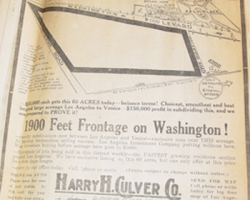
I’ll write less so you can see more. This image is cut from a newspaper before there was a Culver City or the Culver City News. These ads, all pasted in a book (as was the technology at the time), reflect Culver’s thinking and goals. They begin before 1917 –the year that the city was incorporated.
The northernmost street is Venice Boulevard, with little trolleys traveling just above the word “Venice” (upper left) and above “Short Line.” Washington Boulevard is the heavy upper line, and the easterly heavy line (running north and south) reads “Inglewood Road.” The street on the west (left) was then called “Motordome Road,” which is probably what we know as Centinela Avenue today. The lower light line is now Culver Boulevard, but was then Putnam.
Under the words “Harry H. Culver Co.,” the “acreage” arrow points west to Venice and east to Los Angeles. The address for the company was 322-23-24 Story Building (in downtown L.A., where Culver had his office before Main Street was developed). The ad shows a stop for the Redondo & Playa del Rey Electric, which states it is “only 35 minutes to 4th & Hill streets.” This advertisement says “$30,000 cash gets this 60 ACRES today. $150,000 profit in subdividing this and we are prepared to PROVE it!”
This helps substantiate Culver’s plan to establish his city and let L.A./Venice grow to us and us to them, which is exactly what happened. It also reminds us that Washington Boulevard stretched from L.A. to Abbot Kinney’s resort of Venice, and how important it was for our city to have commercial development along it. The upper right portion shows an area of Mar Vista and the interesting planning around an oval, with streets we know as Marcasel Avenue and East Boulevard. Ads like this, along with city records, help us date areas like the west end of our city.


